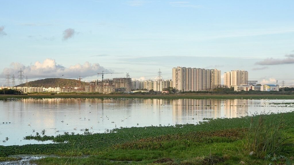

Court file, 18 Nov 2026Wetland Watch
Madras High Court refuses to lift the construction freeze as Tamil Nadu faces unresolved questions over wetland boundaries, a proposed 96% reduction in the interim protection zone, illegal dumping and Chennai’s flood resilience.
Chennai, 20 November 2026. MyOMR Wetland Watch.
The argument. Judicial restrictions can prevent further damage. They cannot substitute for an accurate wetland boundary, functioning drainage, effective waste enforcement and environmental governance the public can check. On 18 November 2026 the Madras High Court refused to lift the Pallikaranai construction freeze or approve a 128.19-hectare interim zone. The restriction is a status quo while the Supreme Court supervises the wetland boundary. It is not a finding that every plot within one kilometre is protected marsh. Court orders can limit new damage. They do not, by themselves, fix the boundary, keep drains open, stop illegal dumping, or govern the wetland in public.
What the judgment actually establishes
On 18 November 2026 the First Division Bench of Chief Justice Sushrut Arvind Dharmadhikari and Justice G. Arul Murugan disposed of the writs challenging the National Green Tribunal’s 24 September 2025 direction. That direction told CMDA not to grant planning permission inside the Pallikaranai Ramsar site and its one-kilometre zone of influence until an integrated management plan is finalised. CMDA froze fresh permissions on 9 October 2025. Live Law reported the High Court ruling as 2026 LiveLaw (Mad) 553. Bar and Bench reported the lead matter as CREDAI versus the Member Secretary.
The Bench held that it would not redraw the line while the Supreme Court is already monitoring ground-truthing and boundary demarcation of this wetland. In words carried by Live Law and Bar and Bench, the court said judicial discipline requires a High Court to refrain from parallel or conflicting orders that alter the wetland’s protective perimeter. The Tamil Nadu State Wetland Authority’s revised note of 1 October 2026 was, on the court’s own reading as reported, only a tentative arrangement. The final zone of influence can be notified after ground-truthing, not before.
The court therefore did not let the authority implement a cut from 3,474 hectares to 128.19 hectares across 36 survey numbers. On those two figures, that cut is about 96 percent of the area now described as frozen. The 96 percent is MyOMR’s arithmetic. It is not a percentage spoken by the Bench. Bar and Bench reported that the 3,474 hectares run across 15 villages, that about 84.2 percent of that belt is already developed, and that more than 47 planning applications were pending before CMDA.
The Bench also rejected the State’s objection that the writs were not maintainable because an NGT order can be taken to the Supreme Court. Live Law reported the court’s reason: the petitioners were not parties before the Tribunal, and an order affecting landowners across 15 villages had been passed without notice to them. Some petitioners, including holders of private patta land in Sholinganallur, said the interim scientific map had placed their land inside the marsh boundary. The High Court did not decide those boundary disputes. It told the petitioners to seek clarification or modification in the Supreme Court proceedings, or to file there afresh. It directed the Wetland Authority, the Directorate of Survey and Settlement and the National Centre for Sustainable Coastal Management to finish ground-truthing, boundary demarcation and statutory notification under the Wetlands (Conservation and Management) Rules, 2017, and the Supreme Court’s directions.
CMDA member-secretary A.R. Rahul Nadh told The New Indian Express the working consequence: projects that already hold approvals may continue; fresh proposals inside the restricted zone will not be processed. CREDAI-Chennai president Mehul H. Doshi told the same paper the association would move the Supreme Court, and that bank finance for work already under way has been held because the belt is being treated as frozen. That is a real burden on patta holders, buyers and sites that were in the planning system before September 2025. Naming the burden is not the same as granting the smaller map.
The legal line, kept narrow. The Court has not permanently declared every parcel within one kilometre to be protected wetland. It has maintained the status quo while boundary proceedings remain under Supreme Court supervision. An interim planning restriction can still stall a lawful patta plot. That grievance belongs in the record. It does not convert the one-kilometre line into a final wetland boundary, and it does not make the 36-survey-number map the law.
The smaller map was a regulation proposal, not a clearance
Even inside 128.19 hectares, the wetland authority did not ask the court for unrestricted building. It said construction could be regulated parcel by parcel, using hydrology rather than a flat radius. It proposed outright bars on blocking inlet and outlet channels, dumping solid waste or construction debris on drainage paths, letting untreated sewage or effluent into watercourses linked to the wetland, permanently cutting those water links, and siting red-category industry there. Construction, on that draft, would have needed a no-objection from the district-level wetland committee. The State also told the court, as Live Law reported, that the 2017 Wetlands Rules do not prescribe an automatic one-kilometre buffer.
Those sentences describe the damage South Chennai can already see. They were not adopted. The one-kilometre freeze on new permissions continues instead. Neither outcome, by itself, removes a load of waste from the bund.
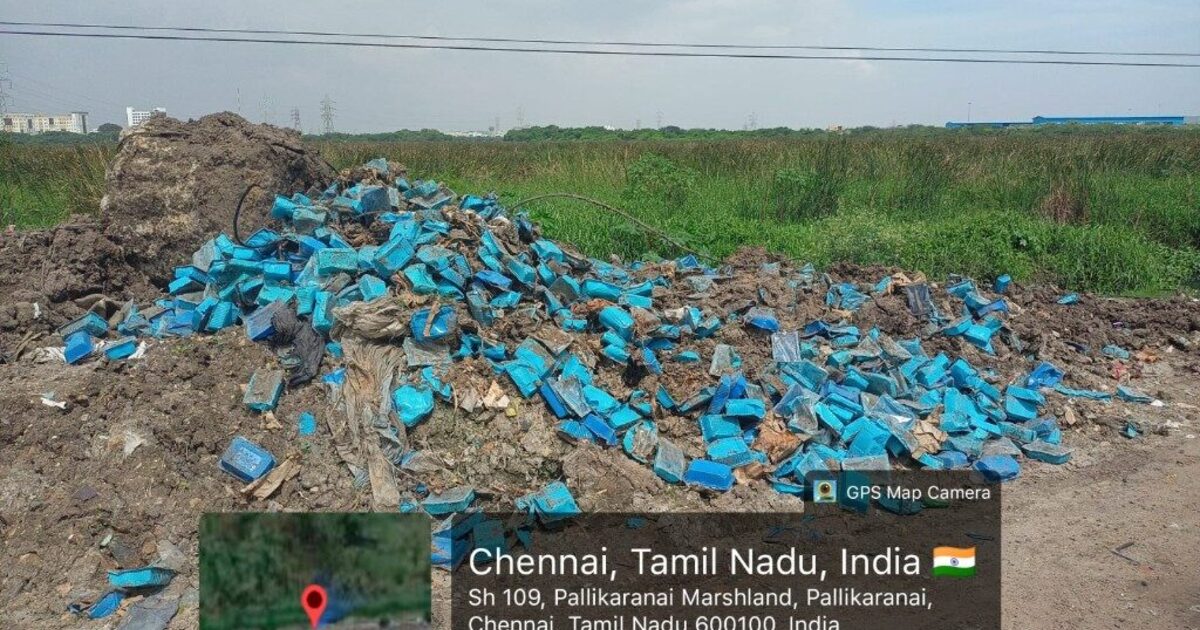
The gap. A planning freeze stops a new CMDA file. It does not stop a truck at night, a leachate drain, or a contractor who treats the marsh margin as spare ground. The State has already written the prohibitions. It has not shown that anyone is enforcing them on the road MyOMR photographed on 14 November.
Our record, four days before the order
On 14 November 2026 MyOMR documented two spots on the Pallikaranai marsh link road. Spot 1, on SH-109, is a concentrated dump of commercial blue food-packaging trays, geotagged at 12.949183, 80.21834 (Pallikaranai, Chennai 600100, 11:25 IST). A brand printed on discarded packaging identifies a product in the waste. It does not, by itself, identify who carried the load. Spot 2, the same morning, showed Greater Chennai Corporation sanitation workers and a Corporation vehicle clearing mixed waste and broken construction material. Clearance is necessary. It is not an investigation.
The full photographic record, the limits of what a label can prove, and the complaint route are in Illegal waste dumping along the Pallikaranai marsh link road. This court update does not replace that file. It shows how far the official argument still sits from it.
The authority’s own draft, the one the High Court declined to install, would have prohibited dumping construction waste on drainage paths connected to this Ramsar site. The photographs show that the prohibition is still a paragraph.
Perungudi is the same hydrology, with a slower clock
The dumpyard and the marsh share water. On 26 October 2026 GCC told The New Indian Express that 29.28 lakh cubic metres of legacy waste had been cleared at Perungudi and 96 acres reclaimed, with Phase II at about 20 percent of 5.50 lakh metric tonnes. On 12 November, resident associations from the Perungudi side asked Additional Chief Secretary Gagandeep Singh Bedi and GCC Commissioner G.S. Sameeran to finish biomining and stop dumping that reaches the marsh. A senior civic official, in reporting of that representation, put reclaimed land at 110 acres, with further work running into 2027, and fresh waste still part of the site story. Standing Committee on Health chairperson G. Shanthakumari has asked for a groundwater note and cameras on vehicles in and out.
Official acres and resident acres still do not match. Biomining that began in October 2021 was supposed to be done in 2024. It is not done. A government order for the remaining legacy waste has been described as starting in March 2027. That is a long monsoon away. Until GCC publishes one dashboard — waste in, waste out, land actually restored, and whether mixed fresh garbage is still arriving while the old mounds are mined — both sets of numbers are claims.
The June fire at the yard already showed what a waste mountain beside a Ramsar wetland does to South Chennai’s air. The 18 November order does not mention that mountain. Residents should not be told that a courtroom map is a substitute for it.
Ground-truthing will be a failure if it only hunts for parcels to release
The Bench was right to refuse a buffer drawn before the boundary is walked. Pallikaranai Marsh Reserve Forest is Ramsar Site 2481, about 1,247.54 hectares, listed in 2022. A one-kilometre planning freeze laid over 15 villages, most of them already built, will hurt owners who are not the people dumping debris. Their files deserve a surveyed answer, survey number by survey number, with notice. The answer is not a quiet reduction from 3,474 hectares to 128 while the Supreme Court is still supervising the edge.
Ground-truthing fails if it only hunts for parcels to release, and it also fails if it treats every patta holder inside the kilometre as an encroacher. The question for each parcel is hydrological. Does it take floodwater into the wetland? Does debris already sit on the feeder? Is sewage entering the same channel the authority’s own draft would have closed? MyOMR’s August explainer, the zone of influence can be regulated rather than blanket-banned, set out the National Centre for Sustainable Coastal Management’s uneven buffer: long stretches of the boundary were proposed at zero to 20 metres, and other stretches at more than 100. Distance from a bund is a weak test. Water is the test. Flood resilience on the OMR corridor depends on that test being done in public.
Until a written order says otherwise, buyers in Pallikaranai, Perumbakkam, Sholinganallur, Perungudi, Velachery, Thoraipakkam and Medavakkam should not rely on an oral assurance. “Your survey number is in the 36” is not a planning permission. The 36-number map was not accepted. A plot inside the operative freeze is under a real restriction, even when it is not marsh land. Get the status in writing before you buy, build, or expect a bank to release funds.
A Chief Minister who has inspected a biogas plant has not yet inspected this
Tamil Nadu Chief Minister C. Joseph Vijay inspected the Chetpet Bio-CNG plant on 20 July 2026 and told officials to process Chennai’s daily waste scientifically. MyOMR argued then, and again on 14 November, that the inspection that matters on this corridor is Perungudi, the marsh edge, and the link road. As of this article, we have still not seen that visit published.
A court that sends petitioners to the Supreme Court, and a government that gives residents a 2027 biomining date, can both be described as process. People who live with the yard do not have a process. They have smell, mosquitoes, leachate risk and a road that still accepts debris. The Chief Minister’s waste file is incomplete until he stands on that ground with the biomining numbers, the CCTV question, and the 14 November photographs in the same briefing.
What should happen now
| Who | What the public can demand |
|---|---|
| CMDA | Publish the villages and survey numbers still inside the operative freeze, mark disputed boundary cases separately, and label the 36-number map as a proposal the High Court did not adopt. |
| TNSWA, Forest Department, CMDA | Finish ground-truthing in public. Include drains, dump spots and the Perungudi edge, not only parcels marked for release. |
| GCC and TNPCB | Inspect the 14 November spots, trace vehicles, and say whether CCTV the Mayor discussed in July 2025 exists there. |
| GCC | One Perungudi dashboard: legacy waste left, fresh waste still received, acres restored, and the date mixed dumping actually stops. |
| Chief Minister’s Office | An on-ground Perungudi–Pallikaranai–SH-109 inspection in this monsoon window. |
| Buyers and banks | Written planning status only. A CREDAI petition in the Supreme Court is not a clearance. |
Report dumping without confronting anyone. GCC 1913 and chennaicorporation.gov.in. TNPCB complaint@tnpcb.gov.in and 1800-425-6750. Send date, time, GPS and photographs.
Frequently asked questions
Did the Madras High Court declare every plot within one kilometre of Pallikaranai a protected wetland?
No. On 18 November 2026 the First Division Bench refused to interfere with the National Green Tribunal restriction and the CMDA freeze that followed it. The restriction continues while the Supreme Court supervises ground-truthing and boundary demarcation. The High Court did not decide that every parcel inside one kilometre is marsh land, and it did not approve the 128.19-hectare interim map. Patta holders and builders may ask the Supreme Court to clarify or modify the zone. Fresh CMDA approvals inside the restricted area are still not being processed.
What interim zone did the wetland authority propose, and did the court accept it?
Tamil Nadu State Wetlands Authority placed a map of 128.19 hectares across 36 survey numbers before the court, against the 3,474 hectares the petitioners say the one-kilometre belt covers. The High Court did not adopt that smaller map. It treated the proposal as tentative and said the final zone of influence can be fixed only after the marsh boundary is ground-truthed, a question already before the Supreme Court.
What would that smaller zone have regulated if the court had accepted it?
The authority said building inside those 128.19 hectares need not be banned on every parcel. It proposed hard stops on blocking natural drains, dumping solid or construction waste on drainage paths, releasing untreated sewage or effluent, permanently cutting hydrological links, and red-category industry. New construction would have needed a no-objection from the district wetland committee. Those lines were a proposal. They are not the order now in force.
What does MyOMR's own record add to this court update?
On 14 November 2026 MyOMR photographed two dumps on the Pallikaranai marsh link road, including a commercial packaging pile geotagged at 12.949183, 80.21834 on SH-109, and a Greater Chennai Corporation crew clearing mixed construction debris nearby. Four days later the High Court was still being asked to shrink a planning map. The waste on the road was already there.
Does the High Court order stop dumping at Perungudi or on the marsh link road?
No. The order decides who may grant planning permission around the Ramsar site. It does not clear legacy waste, stop fresh loads at the Perungudi dumpyard, or identify who left the 14 November material. Greater Chennai Corporation, the Tamil Nadu Pollution Control Board, the Forest Department and the wetlands authority still have that work.
What should a buyer or resident on OMR do this week?
Treat the one-kilometre CMDA freeze as still in force. Do not treat the 36-survey-number map as a building clearance. Get the survey status in writing before you buy, build or expect a bank release. Report dumping, blocked drains and sewage with GPS and photographs to GCC 1913 and TNPCB. This is not legal advice.
Related MyOMR Wetland Watch
- 14 November marsh-link-road dumping, with photographs
- August 2026: regulate the zone, do not pretend the ban is gone
- Earlier adjournment, listed then for 7 September 2026
- What the CMDA approval pause means for patta holders
- Why the Chief Minister should walk Perungudi and the marsh
- June 2026 Perungudi dumpyard fire
- Pallikaranai Ramsar guide
Court reporting used for the 18 November order: Live Law, 19 November 2026, 2026 LiveLaw (Mad) 553; Bar and Bench, 18 November 2026; The Hindu, 18 November 2026; The New Indian Express, 19 November 2026. Earlier biomining figures: The New Indian Express, 26 October 2026, and DT Next, 12 November 2026, as already recorded in MyOMR’s 14 November article. Ramsar Site 2481. Photographs: MyOMR, 14 November 2026.
Editorial note. This is a news report and an editorial judgment. It is not a legal opinion on any plot. The Court maintained an interim planning restriction. It did not hold that every parcel inside one kilometre is protected wetland. The 96 percent comparison is MyOMR’s arithmetic from the 3,474-hectare and 128.19-hectare figures on the record. It is not a figure spoken by the Bench.